
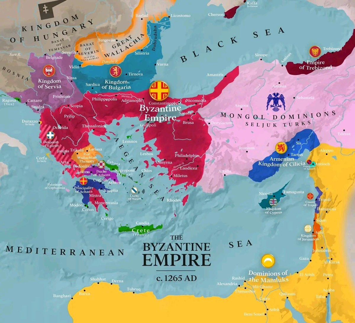
@savageupdatesThe Byzantine Empire existed around 1265 AD
元の投稿を見る@savageupdatesThe Byzantine Empire existed around 1265 AD
元の投稿を見る@savageupdatesさんの写真· Oct 6, 2026· Info/Editorials
This is a historical map depicting the Byzantine Empire around 1265 AD. The focus is on the territorial extent of the Byzantine Empire and its surrounding political entities. The map uses distinct colors to differentiate between the Byzantine Empire, the Kingdom of Hungary, the Kingdom of Serbia, the Kingdom of Bulgaria, the Mongol Dominions of Seljuk Turks, the Armenian Kingdom of Cilicia, the Dominions of the Mamluks, and other smaller principalities and duchies. The overall style is informative and educational, typical of historical cartography. A notable detail is the inclusion of various city names and geographical features like seas and rivers, along with emblems for some of the larger political powers. The on-screen text clearly labels "THE BYZANTINE EMPIRE c. 1265 AD".
 2OnlyFans spending by country
 17 states capital and largest city
 Europe regional food map
 22026 most expensive cities property prices
 2Nobel Laureates by Country ranking
 registered firearms per 100 people in Europe
 2Cities where people live to 100
 U.S. Homicide Rates by County
 2Entalula Beach Philippines ranking
 25 Attack Helicopters by Year
 Companies profit per $100 revenue
 Made in China brands map
 world map of 1700 urban centers
 2Hurun Global Rich List 2026 billionaire cities
 3Giorgia Meloni Italy
 Sheep density map of Europe
 2Numbeo Safety Index 2026 top cities
 4India Destination of the Year 2027
@savageupdatesThe Byzantine Empire existed around 1265 AD
元の投稿を見る@savageupdatesさんの写真· Oct 6, 2026· Info/Editorials
This is a historical map depicting the Byzantine Empire around 1265 AD. The focus is on the territorial extent of the Byzantine Empire and its surrounding political entities. The map uses distinct colors to differentiate between the Byzantine Empire, the Kingdom of Hungary, the Kingdom of Serbia, the Kingdom of Bulgaria, the Mongol Dominions of Seljuk Turks, the Armenian Kingdom of Cilicia, the Dominions of the Mamluks, and other smaller principalities and duchies. The overall style is informative and educational, typical of historical cartography. A notable detail is the inclusion of various city names and geographical features like seas and rivers, along with emblems for some of the larger political powers. The on-screen text clearly labels "THE BYZANTINE EMPIRE c. 1265 AD".
まだコメントはありません。最初のコメントを投稿しましょう!
2OnlyFans spending by country17 states capital and largest cityEurope regional food map22026 most expensive cities property prices2Nobel Laureates by Country rankingregistered firearms per 100 people in Europe2Cities where people live to 100U.S. Homicide Rates by County2Entalula Beach Philippines ranking25 Attack Helicopters by YearCompanies profit per $100 revenueMade in China brands mapworld map of 1700 urban centers2Hurun Global Rich List 2026 billionaire cities3Giorgia Meloni ItalySheep density map of Europe2Numbeo Safety Index 2026 top cities4India Destination of the Year 2027
まだコメントはありません。最初のコメントを投稿しましょう!